Public meeting hears of need for more affordable housing to be part of plan for Villiers Island in the Port Lands
By AMARACHI AMADIKE, Local Journalism Initiative Reporter
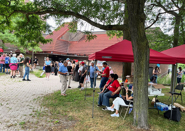
The City of Toronto, along with Waterfront Toronto, hosted a public consultation meeting to discuss the housing targets at the proposed Villiers Island, a new community being developed in the Port Lands.
At the meeting were representatives for Waterfront Toronto as well as Toronto-Danforth Councillor Paula Fletcher who has advocated for more affordable housing units in the development taking place in the southern end of her ward for years.
“This is such great news. I’ve worked very hard to get City Council to increase the affordable housing planned for Villiers Island to 30 per cent.” said Fletcher in a press release prior to Monday, June 19, meeting. “Everyone should have a chance to live on our new Waterfront.”
The meeting, which garnered more than 150 community members at its peak, featured in-depth analysis of the Villiers Island proposal including the potential number of affordable residential units that can be created, density of public lands, massing, and much more.
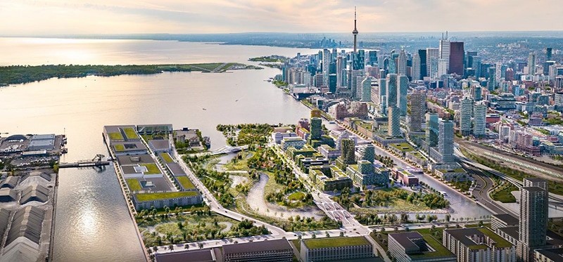
Although the proposal is still in its initial phase (including exploring changes to the built form of Villiers Island to support additional housing),Waterfront Toronto members presented concepts to the public which will be developed and refined in the next phase expected to begin in July.
According to Waterfront Toronto, there are currently three approaches for increasing density on the island that are being discussed.
The first approach will increase density south of the Keating Channel and on the northern blocks. The second option explores increasing density on the western blocks with tall towers along New Cherry Street gateway and west blocks, while the third approach focuses on central intensification between New Cherry and New Munition streets.
Developers refrained from intensifying the eastern block with tall towers in order to “avoid shadows on the new river channel”, according to Christopher Glaisek, Chief Planning and Design Officer at Waterfront Toronto.
All three options aim to provide anywhere from 6,000 to 7,000 units of housing as opposed to the 4,865 in the currently approved precinct plan for the area.
The biggest concern for most in attendance was the need for affordable units in the development.
“The lands that are city lands are the ones that we’re talking about for the 30 per cent [affordable units],” said Fletcher. “But the development applications that are currently in by private owners have no proposed affordable housing.”
She highlighted the “sad state of affairs” the city finds itself in as the provincial government of Premier Doug Ford altered Toronto’s inclusionary zoning in order to push forward the Ontario’s More Homes Built Faster Act.
“We’ll do our best on all the lands that we have control over,” said Fletcher on setting minimums for affordable housing in residential development proposals.
In 2021, Fletcher, who is also vice chair of Toronto’s Planning and Housing Committee, proposed a motion which emphasized the importance of adding affordable housing to the Villiers Island plan.
The following year, with support from Toronto Council, her motions increased affordable housing and density targets from 20 to 30 per cent for the planned mixed-use community on city-owned land.
“More density will have to be added to meet our 30 per cent housing target,” said Fletcher. “It will allow for a truly mixed community of co-operative, rent-geared-to-income, seniors and mid-range rental housing on this impressive new waterfront site being created out of the Port Lands Flood Protection Project.”
Other areas of importance identified by community members at the June 19 meeting were transit connectivity and infrastructure; a 30-kilometre-per-hour speed limit to ensure a “slow-living waterfront precinct”; affordable home ownership; as well as the need to “create a network” of spectacular open spaces.
Many are hoping that the developer plans prioritize public access to water edges as well as the preservation of the lake and park views.
“Villiers Island can be a shining example of how we can help solve the housing crisis by utilizing city-owned land and smart planning policies to create much needed purpose-built affordable housing,” said Fletcher.
The developers for Villiers Island are expected to report back to the public in Phase Three of the planning process (between September and October of this year) with a more detailed version of their proposal which will include specifics on how many affordable units will be created through the project.
Waterfront Toronto is a partnered corporation created by the City of Toronto, Province of Ontario and the Government of Canada to oversee and deliver the revitalization of Toronto’s waterfront. The Port Lands initiative aims to transform 800 hectares of brownfield lands on Toronto’s waterfront into sustainable mixed-use communities while also naturalizing the mouth of the Don River as it meets Lake Ontario.
For more information on the Villiers Island development, visit https://www.waterfrontoronto.ca/our-projects/villiers-island

Amarachi Amadike is a Local Journalism Initiative Reporter for Beach Metro Community News. His reporting is funded by the Government of Canada through its Local Journalism Initiative.